


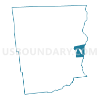
Voting District 120006, Clinton County, New York
About
Outline

Summary
| Unique Area Identifier | 626050 |
| Name | Voting District 120006 |
| County | Clinton County |
| State | New York |
| Area (square miles) | 16.91 |
| Land Area (square miles) | 4.11 |
| Water Area (square miles) | 12.80 |
| % of Land Area | 24.31 |
| % of Water Area | 75.69 |
| Latitude of the Internal Point | 44.72881910 |
| Longtitude of the Internal Point | -73.39069590 |
Maps

Graphs
Select a template below for downloading or customizing gragh for Voting District 120006, Clinton County, New York


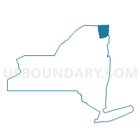
Neighbors
Neighoring Voting District (by Name) Neighboring Voting District on the Map
- Voting District 030001, Clinton County, NY
- Voting District 030003, Clinton County, NY
- Voting District 030005, Clinton County, NY
- Voting District 120001, Clinton County, NY
- Voting District 120007, Clinton County, NY
- Voting District 120009, Clinton County, NY
- Voting District 130201, Clinton County, NY
- Voting District 130503, Clinton County, NY
- Voting District 130601, Clinton County, NY
- Grand Isle Voting District, Grand Isle County, VT
Top 10 Neighboring County Subdivision (by Population) Neighboring County Subdivision on the Map
- Plattsburgh city, Clinton County, NY (19,989)
- Plattsburgh town, Clinton County, NY (11,870)
- Beekmantown town, Clinton County, NY (5,545)
- Grand Isle town, Grand Isle County, VT (2,067)
Top 10 Neighboring Place (by Population) Neighboring Place on the Map
Top 10 Neighboring Elementary School District (by Population) Neighboring Elementary School District on the Map
Top 10 Neighboring Unified School District (by Population) Neighboring Unified School District on the Map
- Plattsburgh City School District, NY (19,657)
- Beekmantown Central School District, NY (13,387)
- Peru Central School District, NY (13,328)
Top 10 Neighboring State Legislative District Lower Chamber (by Population) Neighboring State Legislative District Lower Chamber on the Map
Top 10 Neighboring State Legislative District Upper Chamber (by Population) Neighboring State Legislative District Upper Chamber on the Map
Top 10 Neighboring 111th Congressional District (by Population) Neighboring 111th Congressional District on the Map
Top 10 Neighboring Census Tract (by Population) Neighboring Census Tract on the Map
- Census Tract 1006, Clinton County, NY (5,545)
- Census Tract 1009, Clinton County, NY (5,128)
- Census Tract 1008, Clinton County, NY (4,731)
- Census Tract 202, Grand Isle County, VT (3,698)
- Census Tract 1021, Clinton County, NY (2,120)
- Census Tract 1014, Clinton County, NY (1,919)